
Mauritania · Adrar Plateau · Geological Wonder
The Eye of
Africa
Stand inside the Richat Structure — a 45-kilometre geological enigma visible from space, hidden in the heart of the Sahara near the ancient city of Ouadane.
Scroll
The more people, the lower the price per person.
This trip has a minimum group size requirement.
Find a departure that needs more people — pay the group rate
Share this trip and come back once you have enough people
We match solo & small groups regularly — we'll find a solution
Travel with others — pay the best group rate
Share the trip — travel together for less
We'll confirm within 24 hours via WhatsApp or email.
Share this trip with someone who might want to join you.
Mauritania · Adrar Plateau · Geological Wonder
Stand inside the Richat Structure — a 45-kilometre geological enigma visible from space, hidden in the heart of the Sahara near the ancient city of Ouadane.
Earth's Greatest Enigma
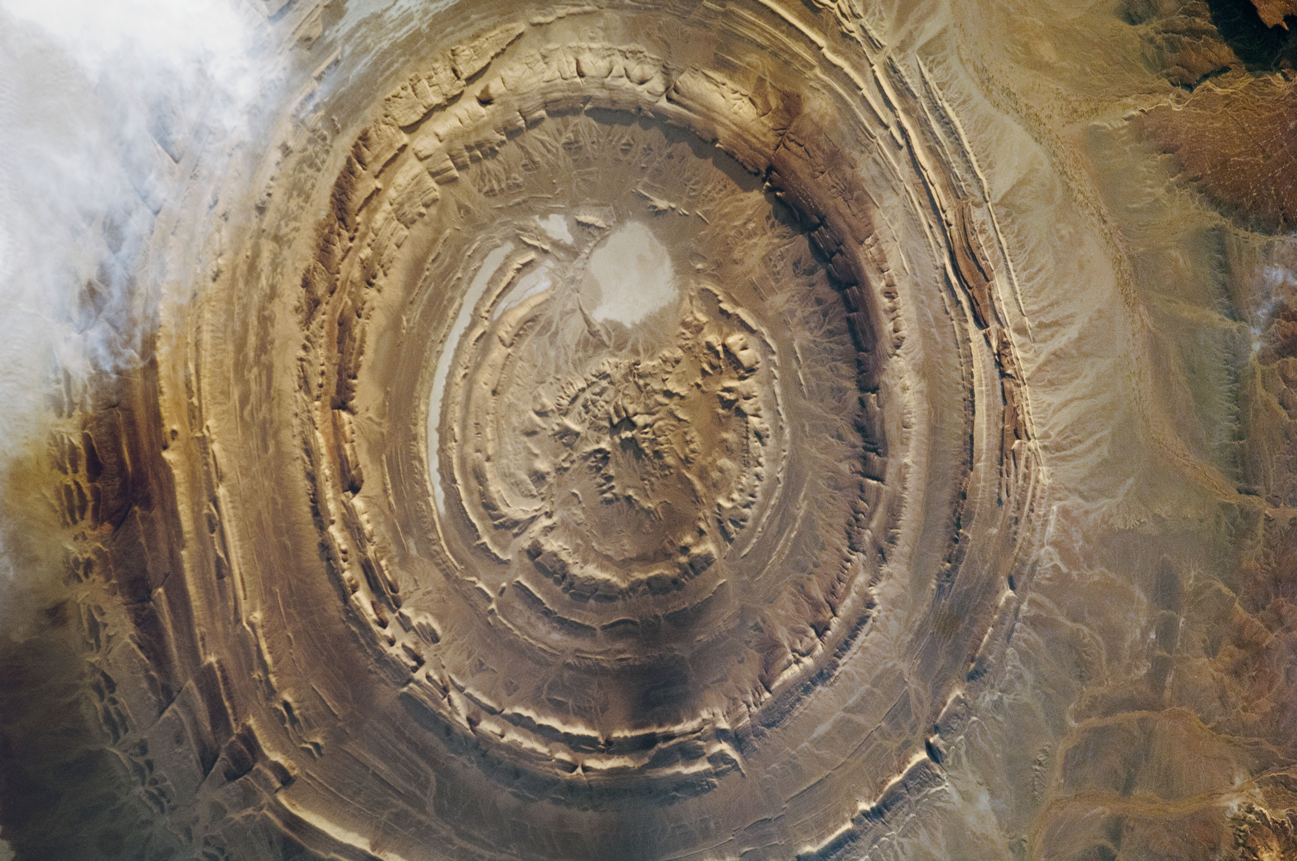
The Richat Structure — known as the Eye of Africa or Guelb er Richat — is one of the most visually striking geological formations on the planet. From space, it appears as a massive concentric bullseye, 45 kilometres in diameter, set in the flat desert of the Adrar Plateau in western Mauritania. Astronauts have used it as a landmark since the earliest days of space flight.
First documented in 1916 by French military surveyors, the structure was initially thought to be a meteorite impact crater. But decades of geological study — including the pioneering work of Théodore Monod in the 1930s and NASA's aerial photography from 1965 — revealed something more complex. The Richat Structure is the product of geological uplift and differential erosion: layers of sedimentary rock, each with different hardness, eroded at different rates over hundreds of millions of years to create the concentric rings visible today.
On the ground, you don't see the eye — you stand inside it. The rings become ridges and valleys, cliffs and dry riverbeds, stretching to the horizon in every direction. It is only from above — from a satellite, a plane, or the rim of the outer escarpment — that the structure's true shape becomes apparent. The scale is almost incomprehensible.
The Richat Structure — a geological wonder visible from space. Standing inside its 50km-wide rings, you understand why ancient geographers thought they'd found Atlantis. Located 35km from Ouadane, deep in the Adrar plateau.
The great paradox of the Eye of Africa is that it is one of the most visible landmarks from orbit, yet almost invisible when you stand within it. The concentric rings — spanning 45 kilometres — dissolve into the surrounding terrain at ground level. You need a drone, a high vantage point, or a satellite image to grasp the full shape. This tension between what is seen from above and experienced below is what makes visiting the Richat Structure so extraordinary.
The Expedition
Walk through the concentric rings of the Richat Structure — ridges of ancient quartzite and sandstone rising from the desert floor, alternating with valleys of softer eroded rock. The colours change throughout the day, from pale grey at noon to deep amber and violet at golden hour. The geology here spans over 100 million years of Earth's history.
Geological wonderThe expedition begins from Ouadane, a UNESCO World Heritage medieval trading city just 30km from the Richat Structure. Founded in the 12th century, Ouadane was once a vital stop on the trans-Saharan caravan routes. Its stone ruins, ancient mosque, and date palm groves provide a powerful historical complement to the geological wonder nearby.
UNESCO cityThe Richat Structure and surrounding area are rich in Paleolithic tools and artifacts. Stone axes, arrowheads, and scrapers are scattered across the surface — evidence that early humans lived and hunted in this region tens of thousands of years ago, when the Sahara was green savannah. Your guide can help identify these finds in situ.
ArchaeologyClimb to the outer rim of the structure for the only ground-level viewpoint from which the concentric pattern begins to emerge. At sunrise or sunset, the shadows cast by the rings create an extraordinary visual — a series of dark and light bands stretching across the desert. This is the moment you understand the scale of what you're standing on.
PanoramaNear the western edge of the Richat Structure lie the ruins of Fort Agouenir, a French colonial-era outpost built in the early 20th century. Now abandoned and slowly being reclaimed by the desert, the fort offers a haunting reminder of Mauritania's colonial past and a dramatic foreground for photographs of the structure's outer rings.
HistoryCamp inside the Eye of Africa itself. As night falls, the temperature drops, the silence is absolute, and the Milky Way appears in staggering detail. Sleeping inside a 45-kilometre geological formation that is visible from the International Space Station is an experience that is difficult to overstate — and impossible to forget.
OvernightA Scientific Mystery
For decades, scientists debated the origin of the Richat Structure. The initial meteorite impact theory was disproved when no shock minerals or impact melt rock were found. The current scientific consensus is that the Eye of Africa is a deeply eroded geological dome: a massive uplift of sedimentary rock that was pushed upward by tectonic forces and then sculpted by hundreds of millions of years of wind and water erosion.
The rings are alternating layers of harder and softer rock. Resistant quartzite ridges survived the erosion, while softer sandstone and limestone valleys were carved away — creating the concentric pattern visible from space. The innermost ring is the oldest rock, dating to the Proterozoic eon, over 500 million years ago. Some researchers have proposed volcanic processes played a role, but the debate continues. The Eye of Africa remains one of geology's great open questions.
“From the ISS, it's unmistakable — a perfect bullseye in the middle of the Sahara. On the ground, you walk through it without seeing it. That's the genius of the Richat Structure.”— Geological survey, Richat Structure 2023
Before You Go
The Richat Structure is reached by 4x4 from Ouadane (approximately 30km, but 1–2 hours over rough terrain). Ouadane itself is accessible from Atar (3–4 hours by 4x4). There are no paved roads to the structure. Yolo handles all transport and navigation.
Sturdy hiking boots, sunscreen, a wide-brimmed hat, cheche/turban, warm layers for cold desert nights, a headlamp, a camera with wide-angle lens, and a drone if you have one (the aerial view is spectacular). Yolo provides camping gear, food, and water.
The full Eye of Africa Expedition includes travel from Atar to Ouadane, 2–3 days exploring the Richat Structure, and optional extensions to Chinguetti or the Iron Ore Train. The structure itself requires at least 2 full days to explore properly.
The cooler months are essential — summer temperatures inside the structure exceed 50°C. Winter days are warm and sunny (25–35°C) with cold nights. The best light for photography and viewing the rings is at sunrise and sunset during the low-sun months.
Exploring the structure involves moderate hiking over rocky terrain, including climbing to rim viewpoints. The remoteness is extreme — there is no shade, no water, and no infrastructure. A reasonable level of fitness is required, and this expedition is best suited to adventurous travellers.
All 4x4 transport from Atar, experienced desert guide, camping equipment, all meals and water, geological briefing, Ouadane city tour, and optional extensions to Chinguetti, Terjit Oasis, or the Iron Ore Train.
Day by Day
8am departure. Tea stop in Akjoujt at 11am. Azoueiga by 3pm. The dunes are enormous and the sunset from the top is the first of several moments on this trip where the scale of what you are standing in becomes hard to process. Camp at the base.
The oasis is the contrast the first day sets up — cold spring water inside a palm gorge hidden in the same plateau that produced yesterday's dunes. We arrive by noon and spend the afternoon doing very little in the best possible way. Guesthouse overnight.
Atar for breakfast, Chinguetti by mid-morning. We spend the afternoon in the old medina and the manuscript libraries before sleeping in a local guesthouse as the wind picks up outside.
The drive east takes three hours through a landscape that gets more austere with every kilometre. Ouadane is the furthest point from Nouakchott on this trip and you feel it — the remoteness is not just geographic. Traditional dinner with a local family. Camp at the walls.
This is the day the trip is named for. We leave at 8am and drive 35–45km into the open desert to the Richat Structure — a 50km-wide geological bullseye that has been eroding out of the Saharan rock for roughly 100 million years. Scientists still debate exactly what caused it. From the ground it is vast and strange and completely disorienting in the best way. We spend the morning walking sections of the outer ring. Back in the vehicle by noon, then we drive deep into the empty plateau and camp — no tracks, no landmarks, nothing.
A long drive back through the Adrar's interior, the landscape completely different from the route north. Wide gravel plains, occasional rock outcrops, the silence of a place that almost no one passes through. Evening camp on open ground.
Back in the city by late afternoon. Seven days. Two UNESCO cities. Africa's tallest dunes. A desert oasis. A geological wonder visible from space.
Ready to See It?
From $879 per person (group of 4). 7-day expedition including all transport, desert camping, Ouadane exploration, meals, guide service, and geological briefing.